2025
Establishing Nationwide Power System Vulnerability Index across US Counties Using Interpretable Machine Learning
Junwei Ma, Bo Li, Olufemi A. Omitaomu, Ali Mostafavi
Applied Energy 2025
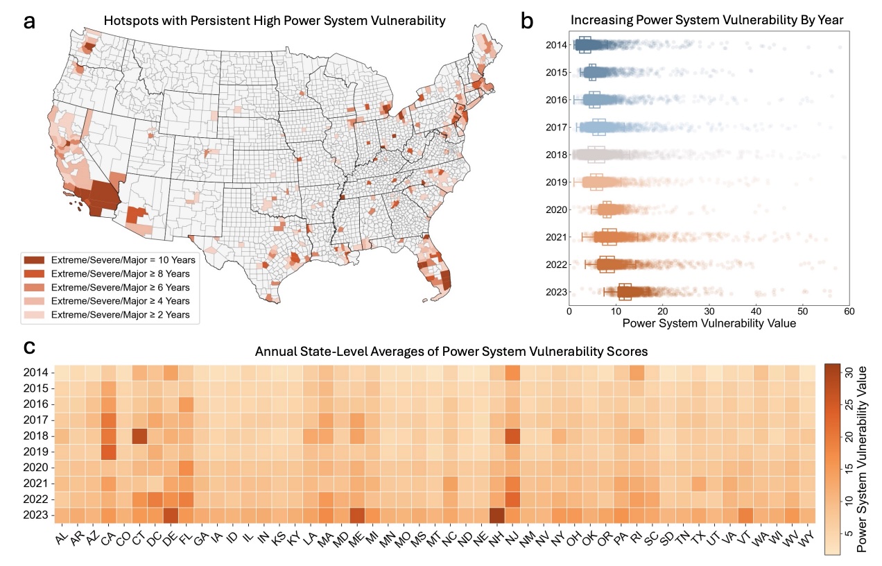
We collected ~179 million power outage records at 15-minute intervals across 3022 US contiguous counties (96.15% of the area) from 2014 to 2023. We developed a power system vulnerability assessment framework based on three dimensions (intensity, frequency, and duration) and applied interpretable machine learning models (XGBoost and SHAP) to compute Power System Vulnerability Index (PSVI) at the county level.
Establishing Nationwide Power System Vulnerability Index across US Counties Using Interpretable Machine Learning
Junwei Ma, Bo Li, Olufemi A. Omitaomu, Ali Mostafavi
Applied Energy 2025
We collected ~179 million power outage records at 15-minute intervals across 3022 US contiguous counties (96.15% of the area) from 2014 to 2023. We developed a power system vulnerability assessment framework based on three dimensions (intensity, frequency, and duration) and applied interpretable machine learning models (XGBoost and SHAP) to compute Power System Vulnerability Index (PSVI) at the county level.
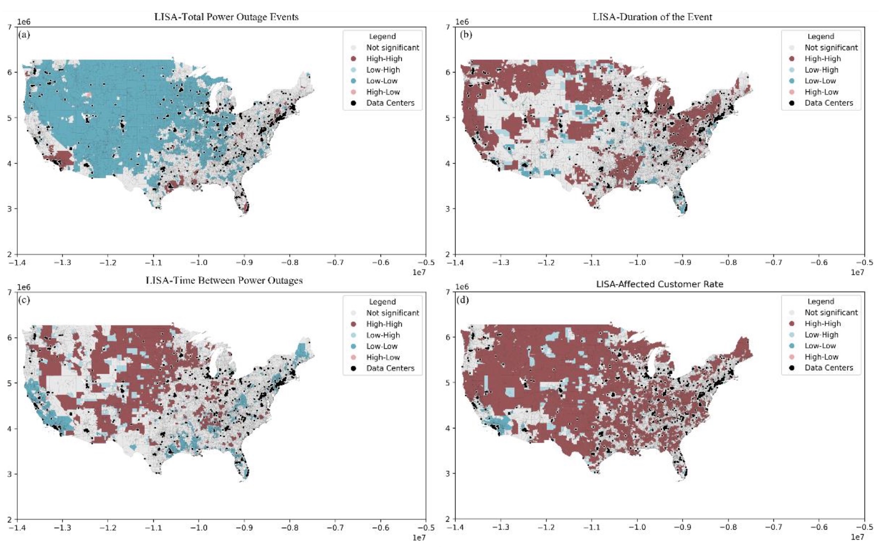
AI Meets Natural Hazard Risk: A Nationwide Vulnerability Assessment of Data Centers to Natural Hazards and Power Outages
Miguel Esparza, Bo Li, Junwei Ma, Ali Mostafavi
International Journal of Disaster Risk Reduction 2025
Our society is on the verge of a revolution powered by Artificial Intelligence (AI) technologies. With increasing advancements in AI, there is a growing expansion in data centers (DCs) serving as critical infrastructure for this new wave of technologies. This technological wave is also on a collision course with exacerbating climate hazards which raises the need for evaluating the vulnerability of DCs to various hazards. Hence, the objective of this research is to conduct a nationwide vulnerability assessment of (DCs) in the United States of America (USA).
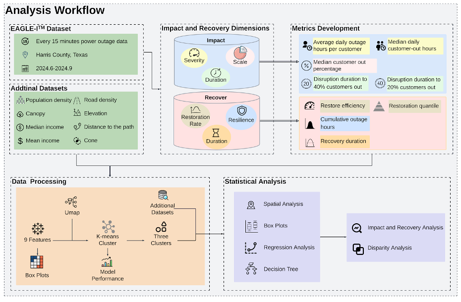
Anatomy of A Historic Blackout: Decoding Spatiotemporal Dynamics of Power Outages and Disparities During Hurricane Beryl
Xiangpeng Li, Junwei Ma, Ali Mostafavi
International Journal of Disaster Risk Reduction 2025
This study investigates the spatial patterns and temporal variations in outage duration, intensity, and restoration/recovery following the 2024 Hurricane Beryl in Houston, Texas. This historic blackout event caused widespread power disruptions across the Houston metropolitan area, leaving more than 2 million customers without power over several days, resulting in over 143 million total customer-outage hours.
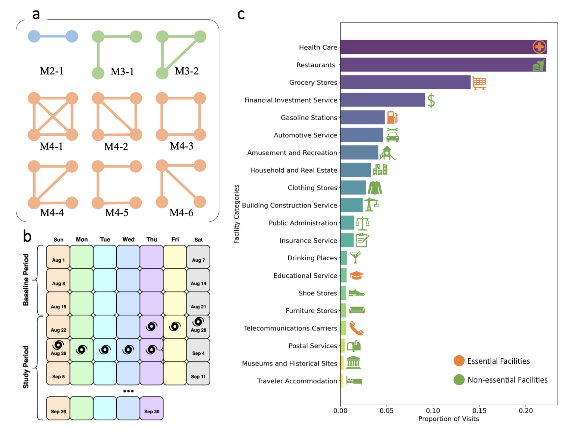
Decoding the Pulse of Community during Disasters: Resilience Analysis Based on Fluctuations in Latent Lifestyle Signatures within Human Visitation Networks
Junwei Ma, Ali Mostafavi
International Journal of Disaster Risk Reduction 2025
In this study, we leveraged data from more than 1.2 million anonymized human mobility communications across 30 parishes in Louisiana to construct a temporal network that tracks visitation to places from which we characterized human lifestyle signatures before, during, and after Hurricane Ida in 2021.
2024
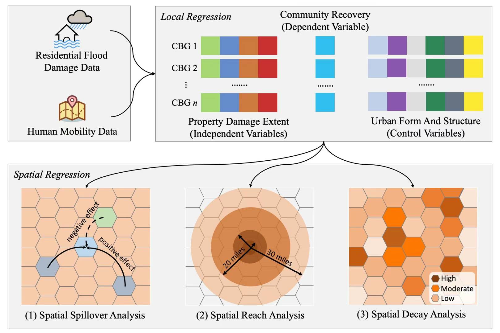
Non-locality and Spillover Effects of Residential Flood Damage on Community Recovery: Insights from High-resolution Flood Claim and Mobility Data
Junwei Ma, Russell Blessing, Samuel Brody, Ali Mostafavi
Sustainable Cities and Society 2024
We combined fine-resolution flood damage claims data (composed of both insured and uninsured losses) and human mobility data (composed of millions of movement trajectories) during the 2017 Hurricane Harvey in Harris County, Texas, to specify the extent to which vulnerability of the built environment (i.e., flood property damage) affects community recovery (based on the speed of human mobility recovery) locally and regionally.
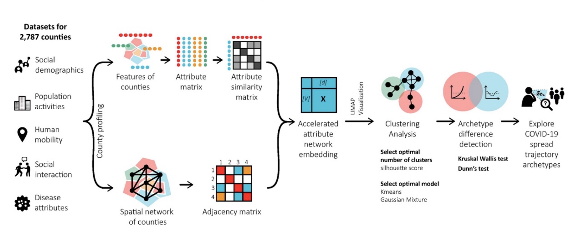
Attributed Network Embedding Model for Exposing COVID-19 Spread Trajectory Archetypes
Junwei Ma, Bo Li, Qingchun Li, Chao Fan, Ali Mostafavi
International Journal of Data Science and Analytics 2024
This study creates a network embedding model capturing cross-county visitation networks, as well as heterogeneous features related to population activities, human mobility, socio-demographic features, disease attribute, and social interaction to uncover clusters of counties in the USA based on their pandemic spread transmission trajectories.
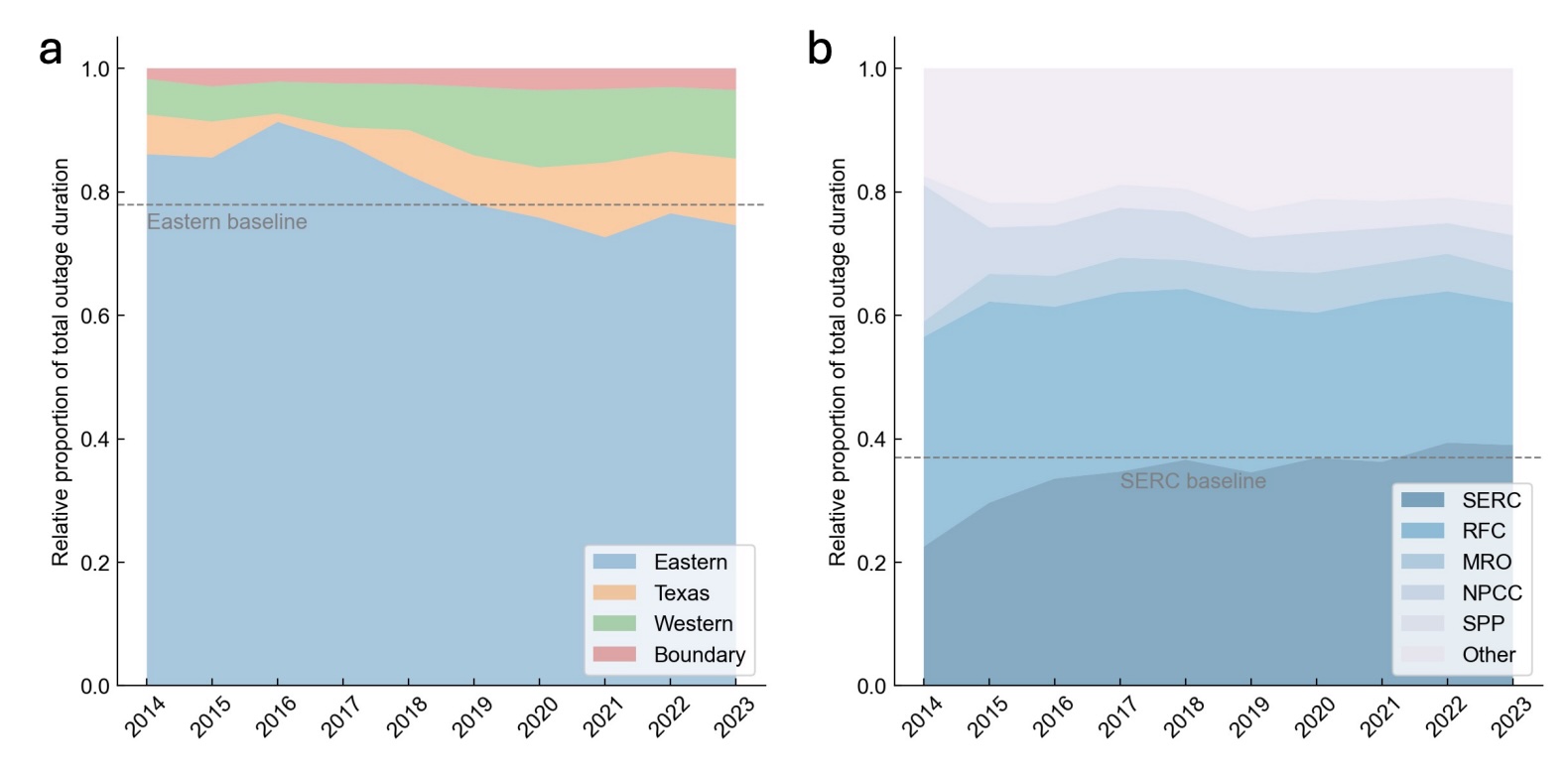
Recent Decade's Power Outage Data Reveals the Increasing Vulnerability of U.S. Power Infrastructure
Bo Li, Junwei Ma, Olufemi A. Omitaomu, Ali Mostafavi
arXiv 2024
In the past ten years, the vulnerability of U.S. power system has consistently been increasing. Counties experienced an average of 999.4 outages over the decade, affecting an average of more than 540,000 customers per county, with disruptions occurring approximately every week.
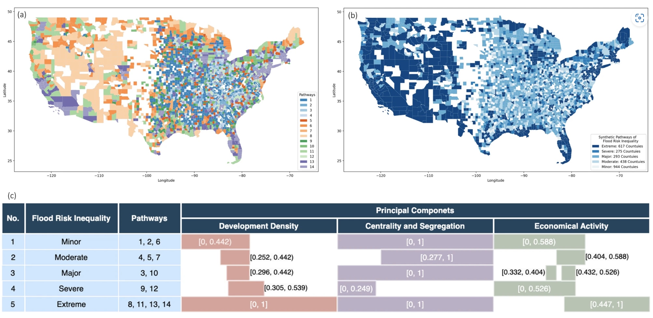
Urban Form and Structure Explain Variability in Spatial Inequality of Property Flood Risk among US Counties
Junwei Ma, Ali Mostafavi
Communications Earth & Environment 2024
We begin by evaluating spatial inequality of property flood risk using the metric of spatial Gini index (SGI), a measure of spatial inequality, for 2567 counties in the United States, identifying notable variations in spatial inequality of property flood risk across counties. We then explore how urban form and structure may be shaping this spatial inequality of property flood risk, by examining eight distinct urban features to assess their potential relationships.
2023
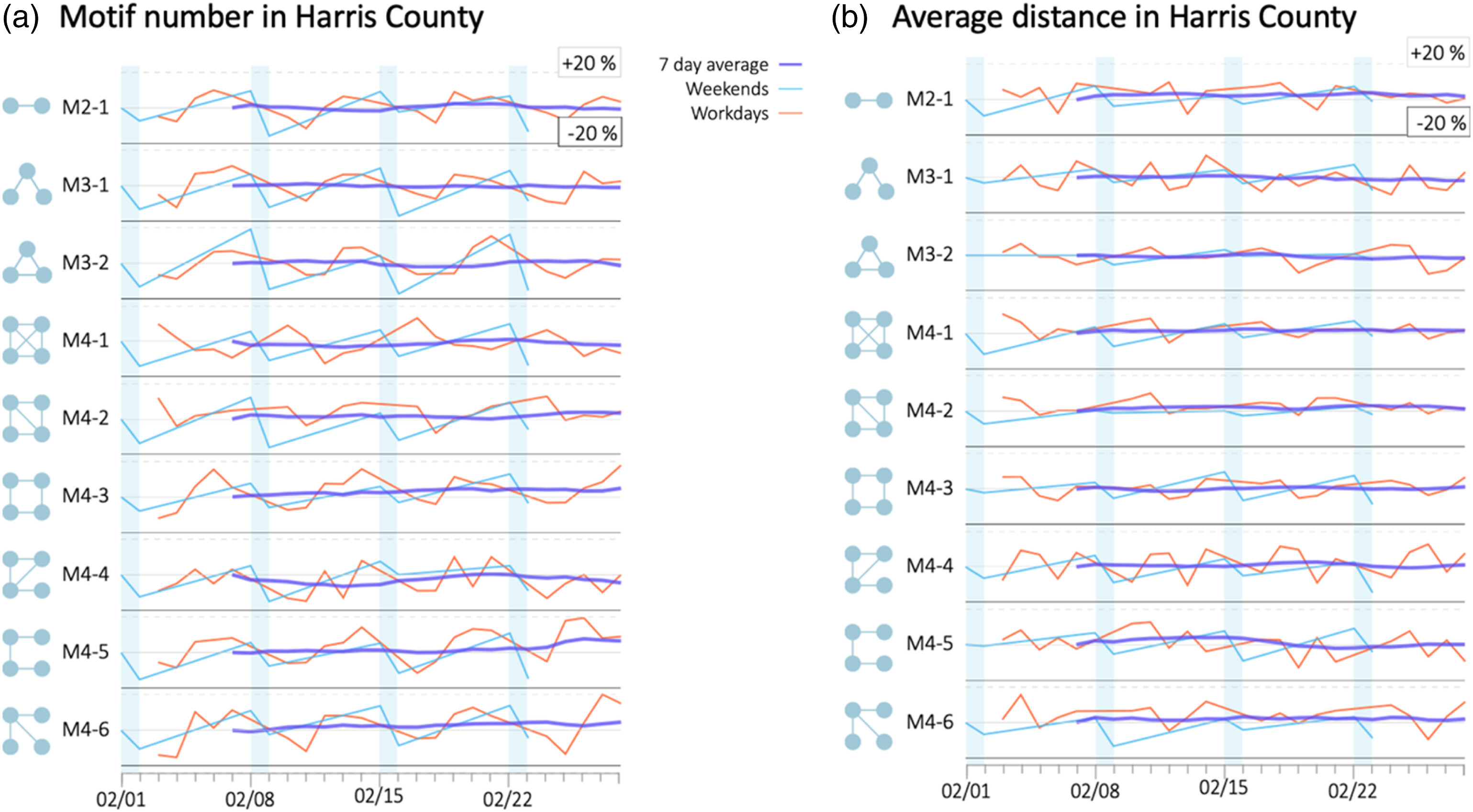
Characterizing Urban Lifestyle Signatures Using Motif Properties in Network of Places
Junwei Ma, Bo Li, Ali Mostafavi
Environment and Planning B: Urban Analytics and City Science 2023
This study constructed networks of places to model cities based on location-based human visitation data. We examined the motifs in the networks of places to map and characterize lifestyle patterns at urban scale.